Tracking and predicting the Deepwater Horizon oil spill in the Gulf of Mexico
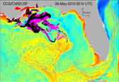
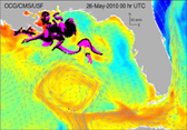
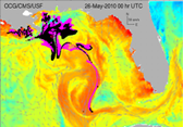
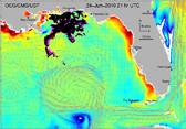
| In a joint effort of the Ocean Circulation Group and the Optical Oceanography
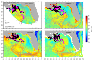
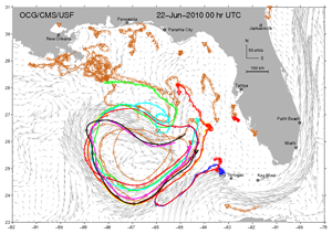
Laboratory at College of Marine Science, University of South Florida to track and predict the Deepwater Horizon (Macondo Well) oil spill spreading, virtual particle trajectories are
simulated based on the surface ocean currents output from six numerical models: the WFS ROMS, the Global HYCOM, the GOM HYCOM, the SABGOM, the RTOFS, and the NCOM IASNFS (see the links below). The latest satellite imagey of surface oil is used to re-initialize
the virtual particle locations so that the starting point of the simulation is as accurate as possible. A series of experiments have
been implemented and the results are listed as follows. It must be recognized that all forecast models have errors that grow with
time for a variety of reasons. So, it is important to consider ensemble analyses from
several different models.
|
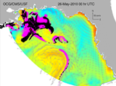
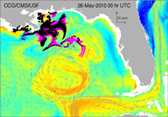
Nowcast/forecast from individual surface oil trajectory models re-initialized with the lastest satellite imagery:
|
|
|
|
|
|
Related publications:
|
Liu, Y., A. MacFadyen, Z.-G. Ji, and R.H. Weisberg (Editors), 2011: Monitoring and Modeling the Deepwater Horizon Oil Spill: A Record-Breaking Enterprise, Geophysical Monograph Series, Vol. 195, 271 PP., ISSN: 0065-8448, ISBN 978-0-87590-485-6. AGU/geopress, Washington, D.C.
|
- Liu, Y., and R.H. Weisberg, 2011: Evaluation of trajectory modeling in different dynamic regions using normalized cumulative Lagrangian separation, Journal of Geophysical Research, 116, C09013, doi:10.1029/2010JC006837.
- Liu, Y., R.H. Weisberg, C. Hu, and L. Zheng, 2011: Trajectory forecast as a rapid response to the Deepwater Horizon oil spill, in Monitoring and Modeling the Deepwater Horizon Oil Spill: A Record-Breaking Enterprise, Geophysical Monograph Series, 195, 153-165, doi:10.1029/2011GM001121.
- Liu, Y., R.H. Weisberg, C. Hu, C. Kovach, and R. Riethmüller, 2011: Evolution of the Loop Current system during the Deepwater Horizon oil spill event as observed with drifters and satellites, in Monitoring and Modeling the Deepwater Horizon Oil Spill: A Record-Breaking Enterprise, Geophysical Monograph Series, 195, 91-101, doi:10.1029/2011GM001127.
- Weisberg, R.H., L. Zheng, and Y. Liu, 2011: Tracking subsurface oil in the aftermath of the Deepwater Horizon well blowout, in Monitoring and Modeling the Deepwater Horizon Oil Spill: A Record-Breaking Enterprise, Geophysical Monograph Series, 195, 205-215, doi:10.1029/2011GM001131.
- Liu, Y., R.H. Weisberg, C. Hu, and L. Zheng, 2011: Combining numerical ocean circulation models with satellite observations in a trajectory forecast system: A rapid response to the Deepwater Horizon oil spill. Proceedings of SPIE Conference 8030, 80300K. doi:10.1117/12.887983.
- Weisberg, R.H., 2011: Coastal Ocean Pollution, Water Quality and Ecology: A Commentary, MTS Journal, 45(2), 35-42.
- Liu, Y., R.H. Weisberg, C. Hu, and L. Zheng, 2011: Satellites, models combine to track Deepwater Horizon oil spill. SPIE Newsroom, doi:10.1117/2.1201104.003575.
- Hu, C., R.H. Weisberg, Y. Liu, L. Zheng, K.L. Daly, D.C. English, J. Zhao, and G.A. Vargo, 2011: Did the northeastern Gulf of Mexico become greener after the Deepwater Horizon oil spill? Geophysical Research Letters, 38, L09601, doi:10.1029/2011GL047184.
- Liu, Y., R.H. Weisberg, C. Hu, and L. Zheng, 2011: Tracking the Deepwater Horizon oil spill: A modeling perspective, EOS Transactions, American Geophysical Union, 92(6), 45-46, doi: 10.1029/2011EO060001. (EOS feature article)
Archived hindcast/forecast of surface oil trajectory:
|
Multiple-model ensemble forecast re-initialized with satellite imagery:
|
| July |
|
|
|
|
|
|
|
|||||||||||||||
| June | ||||||||||||||||||||||
| May | ||||||||||||||||||||||
|
Individual model forecast re-initialized with satellite imagery:
|
| May |
4
|
|
||||||||
| May |
2
|
|||||||||
| May |
1
|
|||||||||
| April |
29
|
|
|
|||||||
| April |
27
|
|
|
|||||||
| April |
25
|
|
|
Surface oil trajectory hindcast/forecast using numerical model only:
WFS ROMS based surface drifter trajectory started from April 20, 2010.
Global HYCOM based drifter trajectory started from April 20, 2010.
Surface oil gtrajectory hindcast experiments from 05/18 to 05/22 (or 05/31) with re-initialization from satellite imagery on 05/18/2010:
|
Satellite-tracked drifter trajectory superimposed on the Global HYCOM simulated ocean currents:
Animations: All USF drifters recently deployed in the eastern Gulf of Mexico. |
Links to the numerical ocean circulation models used in the surface oil trajectory hindcast/forecast:
| WFS ROMS | West Florida Shelf ROMS Hindcast/Forecast System | University of South Florida |
|
Global HYCOM |
Global HYCOM + NCODA Analysis | The HYCOM Consortium |
|
GOM HYCOM |
Gulf of Mexico HYCOM Nowcast/Forecast System | The HYCOM Consortium |
|
SABGOM |
South Atlantic Bight - Gulf of Mexico Nowcast/Forecast System | North Carolina State University |
|
RTOFS |
Real Ttime Ocean Forecast System (Atlantic) | NOAA Environmental Modeling Center |
|
NCOM |
Navy Coastal Ocean Model (NCOM) - IASNFS | Naval Research Laboratory |
Disclaimer:
The nowcast/forecast system and other analyses/data are research products under development. No warranty is made, expressed or implied, regarding accuracy, or regarding the suitability for any particular application. All rights reserved University of South Florida. Copyright University of South Florida 05/06/2010.
See Dr. Yonggang Liu's publications.
Back to Dr. Yonggang Liu's research page.


