Navigation
DISCLAIMER:
The nowcast/forecast system and other analyses/data are research
products under development. No warranty is made, expressed or implied,
regarding accuracy, or regarding the suitability for any particular application. All rights reserved University of South Florida, Ocean Circulation Lab.
Copyright University of South Florida 2010
OCG HF Radar
General Background
To improve our understanding of the workings of the coastal ocean for a variety of environmental applications, including hurricane storm surge and sea level rise, the University of South Florida’s College of Marine Science (USF/CMS) established a real-time Coastal Ocean Monitoring Prediction System (COMPS) for the West Florida Shelf (WFS) and lower Florida Keys track region. COMPS program observing assets consist of arrays of offshore buoys and coastal stations for surface meteorology and in-water measurement of temperature, salinity, currents, and sea level; along with eight High Frequency (HF) Radar sites for offshore surface-current velocity field measurements. Commercially available CODAR and WERA HF-radar systems have been in operation for over twenty years in this challenging region of limited beach availability/access, low wave energy, severe weather, and frequent lightning activity.
Aim
Quantitatively predicting Florida's coastal ocean water properties is dependent on the merging of quality observations with models. The underpinnings are the coastal ocean circulation since the currents are what deliver nutrients from the deep-ocean and the estuaries to the shelf, thereby fueling primary productivity and initiating the complex biological and chemical interactions resulting in the shelf ecology. Commercial and recreational fisheries depend on this as do blooms of harmful red-tide algae. Similarly, safe and efficient maritime commerce depends on our ability to specify currents, sea level, and sea state on the basis of the ocean and atmosphere interactions. Inundation by hurricane storm surge is also matter of great public concern.
Methods
HF-radars provide a means for mapping fields of surface velocity vectors by using the Doppler shift in frequency for radio frequency waves scattered off of surface gravity waves. From these returns a set of radial velocity components is calculated, and given two independent systems, deployed at two different locations along the shoreline, these overlapping radial velocity components are then combined to produce more easily visualized HF-radar Total Vector Surface Velocity Maps for use.
Two types of systems are available: either direction finding with a compact antenna system or beam forming with a linear antenna array. Direction finding HF-radars, such as the commercially available CODAR, use either spatially separate transmit and receive antennas or a compact combined transmit/receive antenna. The transmissions are Omni directional, and the receive antenna senses returns along radial directions at fixed angular and radial distances.
Phased array HF-radar, such as the commercially available WERA, uses a 1 to 4 antenna transmit array and a 12-16 antenna receive array positioned at close intervals along the beach, to record the backscattered radio wave signals. By virtue of the increased number of antennas, it can operate both in a via direction finding and directional beam forming mode.
Existing USF COMPS Combined CODAR and WERA HF-radar Network
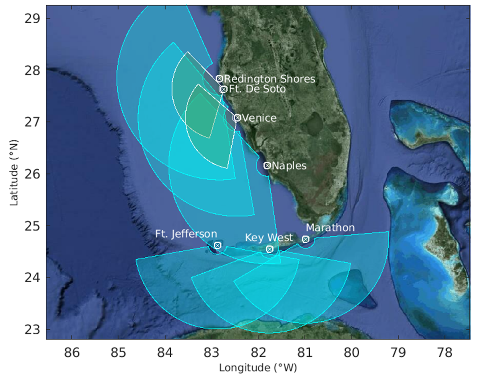
COMPS presently operates six long range CODAR systems [Redington Shores, Venice, Naples, Marathon, Key West Florida, and Fort Jefferson/Dry Tortugas], as well as two WERA systems [Ft De Soto, Venice] on the West Florida Shelf (WFS). The USF CODAR HF-radar systems operate at 5.263 MHz and the WERA HF-radar systems operate at 13.500 MHz. Hourly data from each site is pulled via scripting to a central processing station located at USF/CMS in St. Petersburg, Florida, where the hourly radial velocity data is processed, web served, and provided to the U.S. Integrated Ocean Observing System (IOOS) HF Radar National Network (HFRNet) data collection operations center for ultimate integration into ocean models for various uses such as improved boater safety, supporting U.S Coast Guard Search and Rescue (SAR) operations, and oil spill tracking within the Gulf of America.
Redington Shore (RdSr) Site CODAR Notes: The Long Range CODAR site is located at 18200 Gulf Boulevard, Redington Shores, Florida (27° 49.937' N, 82° 50.032' W) within the Pinellas County, Florida Redington Shores Beach Access Park. Offshore sea surface current speed and direction radial data is provided hourly via a dedicated cellular modem to USF/CMS. This site became operational on 9/24/03.
Venice (Veni) Site CODAR Notes: The site is located at 1200 South Harbor Drive, Venice, FL (27° 04.655' N, 82° 27.096' W) at the U.S. Coast Guard Auxiliary Station number 86. Offshore sea surface current speed and direction radial data is provided hourly via a dedicated cellular modem to USF/CMS. This site became operational on 4/27/04.
Naples (Napl) Site CODAR Notes: The site is located at 1301 Gulf Shore Boulevard N, Naples, FL (26° 09.729' N, 81° 48.632' W) within the City of Naples' Loudermilk Park. Offshore sea surface current speed and direction radial data is provided hourly via a dedicated cellular modem to USF/CMS. Initial operation commenced on 12/22/04 with final operation 4/20/05.
Ft De Soto Park/Tierra Verde Site WERA Notes: The 12 RX antenna WERA site is located at the North Beach Pavilion at Ft DeSoto Park (27° 38.16' N, 82° 44.30' W). Offshore sea surfacecurrent speed and direction radial data is provided hourly via a dedicated cellular modem to USF/CMS. This site became operational on 6/05/10.
Venice Site WERA Notes: TThe 12 RX antenna WERA site is Co-located along with the USF CODAR site at the U.S. Coast Guard Auxiliary Station number 86. Offshore sea surface current speed and direction radial data is provided hourly via a dedicated cellular modem to USF/CMS. This site became operational on 6/13/10.
Marathon (MARA) Site CODAR Notes: The site is located at 56200 Overseas Highway, Marathon, FL 33050 (24° 44.417' N, 80° 59.000' W) within Curry Hammock State Park, Monroe County. Offshore sea surface current speed and direction radial data is provided hourly via a dedicated cellular modem to USF/CMS. This site became operational on 12/20/2019.
Key West (WEST) Site CODAR Notes: The site is located at 2601 S. Roosevelt Blvd., Key West, FL 33040 (24° 33.150' N, 81° 45.996' W) within Smathers Beach City Park, City of Key West, Monroe County. Offshore sea surface current speed and direction radial data is provided hourly via a dedicated cellular modem to USF/CMS. This site became operational on 12/16/2022 with data flow to CORDC commencing on 1/4/2023.
Fort Jefferson (JEFF) Site CODAR Notes: The site is located at Ft Jefferson (JEFF) on the island of Garden Key within the Dry Tortugas National Park (24° 37.596' N, 82° 52.393' W), 70 miles northwest of the City of Key West, Monroe County. Offshore sea surface current speed and direction radial data is provided hourly via a dedicated satellite modem to USF/CMS. This site became operational on 03/05/2024 with data flow to CORDC commencing on 03/07/2024.
Ongoing Discussion/Future Plans
Continuous HF-radar site operation along the WFS and lower Florida Keys has its challenges considering its geographic separation, variations in current/wave climate between the WFS sites (low) and Lower Keys sites (low to high), frequent lightning related ambient noise effects, severe weather and Hurricanes, and increased traffic in and around the FCC licensed ITU transmission bands used. Continuous system site design and construction improvements continue based on sound engineering design and gained in-field knowledge.
In response to a National Academies of Sciences, Engineering, Medicine (NASEM) Gulf Research Program (GRP) goal to increase the understanding and prediction of the Gulf of America Loop Current System (GOA LCS), three additional HF-radar CODAR SeaSonde Ocean Surface Current Measurement systems have recently been installed in the lower Florida Keys region at Marathon, Key West, and Fort Jefferson covering the Straits of Florida region from the Florida Keys to Cuba along with data integration into our existing COMPS/Ocean Circulation Laboratory (OCL) HF Radar network. The requirement for these additional HF Radar systems stem from knowledge gaps in understanding the controls on the GOA LCS and the need for real-time surface current data for assimilation in numerical circulation models of the of the GOA and its inflow and outflow regions between America and Cuba and between Florida and Cuba, respectively.
Acknowledgements
Operational and Maintenance support for the West Florida Coast HF-radar sites has been provided through various NOAA programs including the NOAA IOOS SECOORA program and the USF/CMS. WERA equipment additions were made possible through USF internal R&D funds. Site operations occur through collaborative efforts between the USF COMPS program and Pinellas County, Florida, the City of Naples, Florida, and the U.S. Coast Guard Auxiliary Station Number 86 in Venice, Florida.
Equipment funding for the lower Florida Keys HF-radar sites was provided via a NASEM/GRP competitively awarded grant with Operation and Maintenance support through a collaborative effort between the USF COMPS program, Curry Hammock State Park, the City of Key West, and the Dry Tortugas National Park.
In cooperation with


HF Radar
- OCG CODAR
- OCG WERA
- College of Marine Science
- COMPS Home
- HFRNet
- SECOORA
- IOOS
- OCG HF Radar Home