|
Three long-range (5 MHz) Coastal Ocean Dynamics Application Radar (CODAR) SeaSonde HF radars overlooking an array of as many as eight moored acoustic Doppler current profilers (ADCPs) have operated on the West Florida Shelf since September 2003 for the purpose of observing the coastal ocean currents. HF radar performance on this low-energy (currents and waves) continental shelf is evaluated with respect to data returns, the rms differences between the HF radar and the ADCP radial currents, bearing offsets, and radial velocity uncertainties. Possible environmental factors affecting the HF radar performance are discussed, with the findings that both the low-energy sea state and the unfavorable surface wave directions are the main limiting factors for these HF radar observations of currents on the WFS. Despite the challenge of achieving continuous backscatter from this low-energy environment, when acquired the data quality is good in comparison with the ADCP measurements. The rms differences range from 6 to 10 cm s21 for hourly and from 3 to 6 cm s21 for 36-h low-pass-filtered radial currents, respectively. Bearing offsets are in the range from 2158 to 198. Coherent variations of the HF radar and ADCP radial currents are seen across both tidal and subtidal frequency bands. By examining the HF radar radial velocities at low wave energy, it is found that the data returns decrease rapidly for significant wave heights smaller than 1 m, and that the rms differences between the HF radar and ADCP radials are degraded when the significant wave height is smaller than 0.3 m. Detailed information can be seen in Liu et al. [2011]. Reference: Liu, Y., R.H. Weisberg, C.R. Merz, S. Lichtenwalner, and G.J. Kirkpatrick, 2010: HF radar performance in a low energy environment: CODAR SeaSonde experience on the West Florida Shelf. Journal of Atmospheric and Oceanic Technology, 27(10), 1689-1710. |
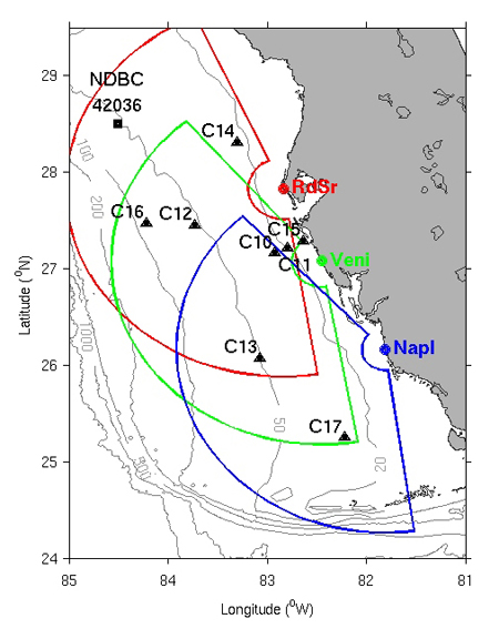
Map of CODAR, ADCP mooring, and wave gauge deployments on the WFS. The areas enclosed by the arcs represent the HF radar radial spatial coverage . Locations of the ADCP moorings are indicated as solid triangles, and the wave gauges are located at moorings C11 and C15 and NDBC buoy 42036, respectively. (This is Figure 1 of Liu et al. [2011]) |