|
Cross-scale coastal ocean modeling The Regional Ocean Modeling System (ROMS) was used in the RISE (River Influence on Shelf Ecosystem) project to simulate the Columbia River estuary-plume-shelf cross-scale system with realistic atmospheric, tidal and river forcing. This NSF funded coastal ocean modeling project was led by Professor Parker MacCready in School of Oceanography, University of Washington. Description of the model configuration can be seen in MacCready et al. [2009]. Performance evaluation of the Columbia River plume model Realistic hindcast of the Columbia River estuarine-plume-shelf circulation in summer 2004 using the Regional Ocean Modeling System nested within the Navy Coastal Ocean Model (NCOM) is quantitatively evaluated with an extensive set of observations. The model has about equal skill at tidal and subtidal properties. Tidal circulation and water properties are best simulated in the estuary, which is strongly forced and damped, but worst on the shelf. Subtidal currents are again best in the estuary. However, subtidal temperature and salinity are best simulated in the surface waters on the shelf, even inside the river plume. A comprehensive skill assessment method is proposed to evaluate the cross-scale modeling system with a focus on the plume. The model domain is divided into five dynamical regions: estuary, near- and far-field plume, near surface and deep layers. A skill score is obtained for each region by averaging the skills of different physical variables, and an overall skill is obtained by averaging the skills across the five regions. This weighting metric results in more skill weight per unit volume in the near surface layer where the plume is trapped and in the estuary. It is also demonstrated, through model/data comparison and skill assessment, that by nesting within NCOM, some important remote forcing, e.g., coastal trapped waves, are added to our model; on the other hand, some biases are also received. With a finer grid and more realistic forcing, our regional model improves skill over a larger-scale model in modeling the shelf-plume circulation. Detaied information can be seen in Liu et al. [2009a]. Columbia River plume patterns in summer 2004 Model hindcasts of the Columbia River plume and coastal ocean circulation in summer 2004 are used to describe the subtidal evolution of plume patterns in response to local wind and to examine the plume influence on shelf circulation. It is found that a bi-directional plume occurs frequently on the Washington/Oregon shelf, during weak upwelling favorable wind events, during weakening of moderate upwelling favorable wind events, and during weak downwelling events. The high frequency of occurrence of the north plume branch indicates that the Columbia River water will have a significant influence on the Washington shelf in summer. Detaied information can be seen in Liu et al. [2009b]. |
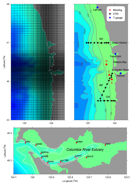
Maps of (top left) model grid, (top right) mooring, CTD and tide gauge stations on the shelf and (bottom) mooring locations in the Columbia River estuary, superimposed on bathymetric contours (units in m). Note that the complete grid also includes a ‘‘river’’ extending about 300 km to the east [MacCready et al., 2009]. (This is Figure 1 of Liu et al. [2009a]) |
Links:
Dr. Parker MacCready, University of Washington
Dr. Barbara M. Hickey, University of Washington
References:
- Liu, Y., P. MacCready, B.M. Hickey, E.P. Dever, P.M. Kosro, and N.S. Banas, 2009a: Evaluation of a coastal ocean circulation model for the Columbia River plume in 2004. Journal of Geophysical Research, 114, C00B4, doi:10.1029/2008JC004929.
- Liu, Y., P. MacCready, and B.M. Hickey, 2009b: Columbia River plume patterns in summer 2004 as revealed by a hindcast coastal ocean circulation model. Geophysical Research Letters, 36, L02601, doi:10.1029/2008GL036447.
- MacCready, P., N. S. Banas, B. H. Hickey, E. P. Dever, and Y. Liu, 2009: A model study of tide- and wind-induced mixing in the Columbia River estuary and plume. Continental Shelf Research, 29, 278-291.
See Yonggang Liu's publications
Back to Yonggang Liu's homepage
(Last updated on 02/18/2011)