|
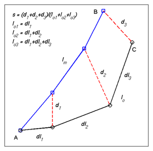
A skill score for trajectory model evaluation: The Lagrangian separation distance (d) between the endpoints of simulated and observed drifter trajectories is often used to assess the performance of numerical particle trajectory models. However, the separation distance fails to indicate relative model performance in weak and strong current regions, such as a continental shelf and its adjacent deep ocean. To overcome this difficulty, Liu and Weisberg [2011] proposed a skill score (ss) based on a ratio (s), which was defined as the cumulative Lagrangian separation distance normalized by the associated cumulative observed trajectory length (Figure 1). The skill score is defined as ss = 1 - s/n ( if s < n); or ss = 0 ( if s >= n), where n is a tolerence threshold. MATLAB codes available for free:
A set of MATLAB codes are provided here as an example on how to apply the skill score:
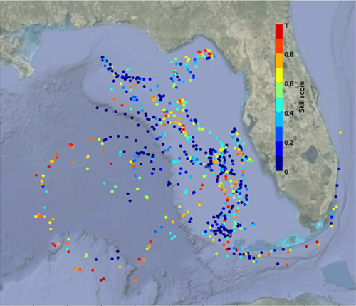
colorbarv4GE.m These MATLAB codes and the associated data can be downloaded as a zip file. Run the code "skill_score_ncls_example.m" to reproduce Figure 2 to the right (a figure in Liu et al. [2014]). This is an example of trajectory model performance evaluation based on one drifter record only. It can be similarly applied to other drifter trajecotries, as many as you have! Application to the trajectory model evaluation in the Gulf of Mexico: This skill score was used to evaluate surface trajectories implied by Global HYCOM hindcast surface currents as gauged against actual satellite-tracked drifter trajectories (Figure 3) in the eastern Gulf of Mexico during the 2010 Deepwater Horizon oil spill. It was found that the new skill score correctly indicated the relative performance of the Global HYCOM in modeling the strong currents of the Gulf of Mexico Loop Current and the Gulf Stream and the weaker currents of the West Florida Shelf (Figure 4). In contrast, the Lagrangian separation distance alone gave a misleading result [ Liu and Weisberg, 2011]. As a follow-on study, the same drifter data set was used to evaluate trajectory model hindcast based on the surface currents derived from satellite altimetry products. It is interesting that these altimetry-based trajectory models have about the same performance, and that they are useful for providing essential information on ocean surface currents of use in water property transports, offshore oil and gas operations, hazardous spill ,itigation, search and rescue, etc. More detailed information can be found in Liu et al. [2014]. This dimensionless skill score is particularly useful when the number of drifter trajectories is limited and neither a conventional Eulerian-based velocity nor a Lagrangianbased probability density function may be estimated. The normalized Lagrangian skill assessment is solely based on the drifter trajectories, and thus prior knowledge of the ocean circulation in the interested region or additional climatological data of the mean circulation patterns are not required. These features make the normalized cumulative Lagrangian separation (NCLS) a practical index for a trajectory model evaluation in situations of rapid response to maritime incidents, such as oil spills and search and rescue operations. |
Figure 1. Illustration of the separation distances (d1, d2, d3) between modeled (blue) and observed (black) endpoints of Lagrangian trajectories. The lengths of observed trajectories are shown as lo. An index (s) is defined as a ratio between the cumulative Lagarangian separation distances and the lengths of the observed trajectory. A skill score is defined as ss = 1 - s/n ( if s < n); or ss = 0 ( if s >= n), where n is a tolerence threshold. (This is Figure 3 of Liu and Weisberg [2011])
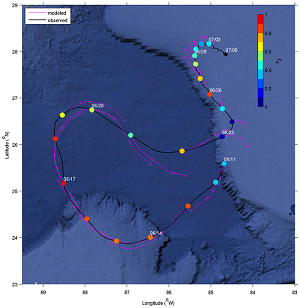
Figure 2. Observed (blakc) and simulated (magenta) trajectories along a drifter path in the eastern Gulf of Mexico. The trajectory model reinitilizes daily from the oberved locations. The closed circles designate the model skill scores after 3 days' simulation (This is Figure 3 of Liu et al. [2014]) |
|
 |
 |
|
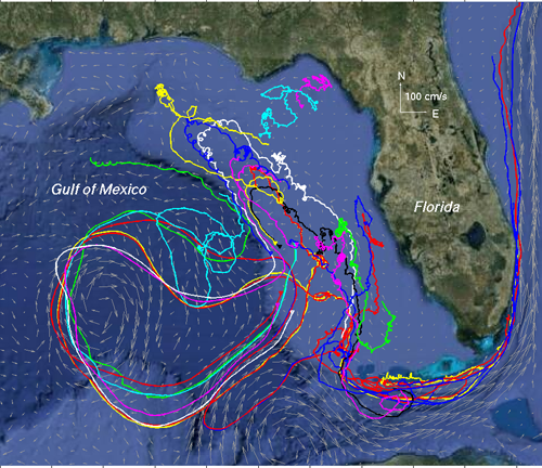
| Figure 3. Satellite-tracked drifter trajectories collected during May–August 2010 in the eastern Gulf of Mexico. Drifter trajectories are differentiated with various colors. (This is Figure 1 of Liu and Weisberg [2011]) | Figure 4. Spatial distribution of the skill score (n = 1) of the Global HYCOM based surface trajectory model after 3 days of simulation. (This is Figure 9 of Liu and Weisberg [2011]) |
References:
- Liu,Y., and R.H. Weisberg, (2011), Evaluation of trajectory modeling in different dynamic regions using normalized cumulative Lagrangian separation, J. Geophys. Res., 116, C09013, doi:10.1029/2010JC006837.
- Liu,Y., R.H. Weisberg, S. Vignudelli, and G.T. Mitchum (2014), Evaluation of altimetry-derived surface current products using Lagrangian drifter trajectories in the eastern Gulf of Mexico, J. Geophys. Res., 119(5), 2827-2842, doi:10.1029/2013JC009710.
Applications in trajectory model evaluation:
Recently, this new skill score finds applications in assessing numerical ocean circulation models [e.g., Mooers et al., 2012; Halliwell et al., 2013]. It also gains popularity in evaluating trajectory models for oil spill and search and rescue operations [Röhrs et al., 2012; Ivichev et al., 2012; Law-Chune, 2012; De Dominicis et al., 2013; Liu et al., 2014; Sayol et al., 2014; Bouffard et al., 2014; etc]. Here is an incomplete list: (more to be added in the future)
- Mooers, C.N.K., E.D. Zaron, M.K. Howard (2012), Final Report for Phase I of Gulf of Mexico 3-D Operational Ocean Forecast System Pilot Prediction Project (GOMEX-PPP), the U.S. Department of Energy.
- Röhrs, J., K.H. Christensen, L.R. Hole, G. Broström, M. Drivdal, and S. Sundby (2012), Observation-based evaluation of surface wave effects on currents and trajectory forecasts, Ocean Dynamics, 62, 1519-1533.
- Ivichev, I., L.R. Hole, L. Karlin, C. Wettre, and J. Röhrs, 2012: Comparison of operational oil spill trajectory forecasts with surface drifter trajectories in the Barents Sea, J. Geol. Geosci., 1:105. doi:10.4172/jgg.1000105.
- Law-Chune, S. (2012), Apport de l’océanographie opérationnelle à l’amélioration de la prévision de dérive océanique dans le cadre d'opérations de recherche et de sauvetage en mer et de lutte contre les pollutions marines (Contribution of operational oceanography to drift forecast for search and rescue operations and marine pollution response), Ph.D. Thesis, Mercator-Océan, Toulouse, France.
2013:
- De Dominicis, M., N. Pinardi, G.Zodiatis, and R. Archetti (2013), MEDSLIK-II, a Lagrangian marine surface oil spill model for short-term forecasting – Part 2: Numerical simulations and validations, Geosci. Model Dev., 6, 1871–1888, doi:10.5194/gmd-6-1871-2013.
2014:
- Halliwell, G., A. Srinivasan, V. Kourafalou, H. Yang, D. Willey, M. Le Hénaff, and R. Atlas (2014), Rigorous evaluation of a fraternal twin ocean OSSE system for the Open Gulf of Mexico, J. Atmos. Oceanic Technol., doi:10.1175/JTECH-D-13-00011.1.
- Sayol, J.M., A. Orfila, G. Simarro, D. Conti, L. Renault, and A. Molcard (2014), A Lagrangian model for tracking surface spills and SaR operations in the ocean, Environmental Modelling & Software, 52, 74–82, http://dx.doi.org/10.1016/j.envsoft.2013.10.013.
- Liu, Y., R.H. Weisberg, S. Vignudelli, and G.T. Mitchum (2014), Evaluation of altimetry-derived surface current products using Lagrangian drifter trajectories in the eastern Gulf of Mexico, J. Geophys. Res., 119, 2827-2842, doi:10.1002/2013JC009710.
- Bouffard, J., F. Nencioli, R. Escudier, A. M. Doglioli, A. Petrenko, A. Pascual, P.-M. Poulain, and D. Elhmaidi (2014), Lagrangian analysis of satellite-derived currents: Application to the North Western Mediterranean coastal dynamics, Advances in Space Research, http://dx.doi.org/10.1016/j.asr.2013.12.020.
- Dominicis, M.D., Falchetti, S., Trotta, F. et al. Ocean Dynamics (2014), A relocatable ocean model in support of environmental emergencies, Ocean Dynamics, 64, 667-688, doi:10.1007/s10236-014-0705-x
- M. Salim, R. K. Nayak, P.C. Mohanthy, S.K. Sasamal, V.K. Dadhwal, C.B.S Dutt & M.S. Rao (2015): Characterization of the Seasonal Circulation Patterns and Its Application on Oil Spill Transport in the Northwestern Continental Shelf of India, Marine Geodesy, DOI: 10.1080/01490419.2015.1008709
- Röhrs, Johannes, 2014: Surface wave effects in the upper ocean and consequences for biological modeling, Ph.D. Thesis, The University of Bergen.
- Michela De Dominicis,Silvia Falchetti, Francesco Trotta, Nadia Pinardi, Luca Giacomelli, Ernesto Napolitano, Leopoldo Fazioli, Roberto Sorgente, Patrick J. Haley Jr., Pierre F. J. Lermusiaux, Flavio Martins, Michele Cocco, 2014: A relocatable ocean model in support of environmental emergencies, Ocean Dynamics, 64, 667-688.
- Joao Janeiro, Anna Zacharioudaki, Ehsan Sarhadi, Augusto Neves, Flavio Martins, 2014:Enhancing the management response to oil spills in the Tuscany Archipelago through operational modelling, Marine Pollution Bulletin, 85,574-589.
- Mooers, C.N.K., P.J. Hogan, and E.D. Zaron (2014), Gulf of Mexico 3-D Operational Ocean Forecast System Pilot Prediction Project (GOMEX-PPP), Final Report to RPSEA.
- Röhrs, J. (2014), Surface wave effects in the upper ocean and consequences for biological modeling, Ph.D. Thesis,The University of Bergen.
2015:
- Sperrevik, A.K., Christensen, K.H., and Röhrs, J. (2015), Constraining energetic slope currents through assimilation of high-frequency radar observations, Ocean Sci., 11, 237-249, doi:10.5194/os-11-237-2015, 2015.
- Ferrer, L., N. Zaldua-Mendizabal, A. Del Campo, J. Franco, J. Mader, U. Cotano, I. Fraile, A. Rubio, Ad. Uriarte, A. Caballero (2015), Operational protocol for the sighting and tracking of Portuguese man-of-war in the southeastern Bay of Biscay: Observations and modeling, Continental Shelf Research, 95, 39-53, doi:10.1016/j.csr.2014.12.011.
- Berta, M., A. Griffa, M. Magaldi, T.M. Ozgokmen, A. Poje, A. Haza, J. Olascoaga (2015), Improved surface velocity and trajectory estimates in the Gulf of Mexico from blended satellite altimetry and drifter data, J. Atmos. Ocean. Technol., 32, 1880-1901.
- Yan, J. L. Wang, L. Chen, L. Zhao, and B. Huang (2015), A dynamic remote sensing data-driven approach for oil spill simulation in the sea, Remote Sens., 7(6), 7105-7125, doi:10.3390/rs70607105.
2016:
- Sotillo, M. G., Garcia-Ladona, E., Orfila, A., Rodriguez-Rubio, P., Maraver, J. C., Conti, D., Padorno, E., Jimenez, J. A., Capo, E., Perez, F., Sayol, J. M., de los Santos, F. J., Amo, A., Rietz, A., Troupin, C., Tintore, J., and Alvarez-Fanjul, E. (2016), The MEDESS-GIB database: tracking the Atlantic water inflow, Earth Syst. Sci. Data, 8, 141-149, doi:10.5194/essd-8-141-2016.
- De Dominicis, M., D. Bruciaferri,R. Gerin,N. Pinardi,P.M. Poulain,P. Garreau,G. Zodiatis,L. Perivoliotis,L. Fazioli,R. Sorgente,C. Manganiell (2016), A multi-model assessment of the impact of currents, waves and wind in modelling surface drifters and oil spill, Deep Sea Res. II, doi:10.1016/j.dsr2.2016.04.002.
- Sorgente, R., C. Tedesco, F. Pessini, M. De Dominicis, R. Gerin, A. Olita, L. Fazioli, A. Di Maio, and A. Ribotti (2016), Forecast of drifter trajectories using a Rapid Environmental Assessment based on CTD observations, Deep Sea Res. II, doi:10.1016/j.dsr2.2016.06.020.
- Wang, Y., Z. Wei, W. An (2016), Development of an oil spill forecast system for off shore China, Chinese Journal of Oceanology and Limnology, 34, 859-870, http://dx.doi.org/10.1007/s00343-016-5009-1.
- Ngodock, H., M. Carrier, I. Souopgui, S. Smith, P. Martin, P. Muscarella, and G. Jacobs (2016), On the direct assimilation of along-track sea-surface height observations into a free-surface ocean model using a weak constraints four-dimensional variational (4D-Var) method, Q.J.R.Meteorol.Soc., 142, 1160-1170.
- Carlson, D.F., A. Griffa, E. Zambianchi, G. Suaria, L. Corgnati, M.G. Magaldi, P.-M. Poulain, A. Russo, L. Bellomo, C. Mantovani, P. Celentano, A. Molcard, and M. Borghini (2016), Observed and modeled surface Lagrangian transport between coastal regions in the Adriatic Sea with implications for marine protected areas, Cont. Shelf Res., 118, 23-48, doi:10.1016/j.csr.2016.02.012
- Roarty, H., S. Glenn, and A. Allen (2016), Evaluation of environmental data for search and rescue, IEEE Oceans 2016, doi:10.1109/OCEANSAP.2016.7485535.
- Sotillo, M.G., A. Amo-Baladron, E. Padorno, E. Garcia-Ladona,A . Orfila, P. Rodriguez-Rubio, D. Conti, J.A. Jimenez Madrid, F.J. de los Santos, and E. Alvarez Fanjul (2016), How is the surface Atlantic water inflow through the Gibraltar Strait forecasted? A lagrangian validation of operational oceanographic services in the Alboran Sea and the Western Mediterranean, Deep Sea Res. I, doi:10.1016/j.dsr2.2016.05.020.
- Tudor, M., and I. Janekovic (2016), Modelling origin and transport fate of waste materials on the southeastern Adriatic coast (Croatia), doi:10.15233/gfz.2016.33.3.
2017:
- Carlson, D. F.; Suaria, G.; Aliani, S.; Fredj, E.; Fortibuoni, T.; Griffa, A.; Russo, A.; Melli, V. (2017), Combining litter observations with a regional ocean model to identify sources and sinks of floating debris in a semi-enclosed basin: the Adriatic Sea, Frontiers in Marine Science, 4:78. doi:10.3389/fmars.2017.00078.
- Lei, L; He, W. (2017), Simulation of oil transport after oil spill in the Bohai Sea, Applied Mechanics and Civil Engineering VI.
- Deborah French-McCay, Tayebeh Tajalli Bakhsh, and Malcolm L. Spaulding (2017), Evaluation of Oil Spill Modeling in Ice Against In Situ Drifter Data from the Beaufort Sea, International Oil Spill Conference Proceedings: May 2017, Vol. 2017, No. 1, pp. 1523-1542. https://doi.org/10.7901/2169-3358-2017.1.1523
- Joao Janeiro; Augusto Neves; Flavio Martins; Francisco Campuzano (2017), Improving the response to operational pollution in the South Iberian coast: A Super-Ensemble backtracking approach, IEEE Xplore, doi:10.1109/EXPAT.2017.7984419
- J. Janeiro; A. Neves; F. Martins; P. Relvas (2017), Integrating technologies for oil spill response in the SW Iberian coast, Journal of Marine Systems, https://doi.org/10.1016/j.jmarsys.2017.04.005
- Luke Phillipson; Ralf Toumi (2017), Impact of data assimilation on ocean current forecasts in the Angola Basin, Ocean Modelling, https://doi.org/10.1016/j.ocemod.2017.04.006
- Rufu Qin; Liangzhao Lin; Cuiping Kuang; Tsung-Chow Su; Xiaodan Mao; Yusheng Zhou (2017), A GIS-based software for forecasting pollutant drift on coastal water surfaces using fractional Brownian motion: A case study on red tide drift, Environmental Modelling & Software, https://doi.org/10.1016/j.envsoft.2017.03.003
- George Zodiatis, Giovanni CoppiniLeonidas PerivoliotisRobin LardnerTiago AlvesNadia Pinardi, Svitlana LiubartsevaMichela De DominicisEvi BourmaAntonio Augusto Sepp Neves(2017), Numerical Modeling of Oil Pollution in the Eastern Mediterranean Sea, The Handbook of Environmental Chemistry, https://link.springer.com/chapter/10.1007/698_2017_131
- Deborah P French-McCay; Tayebeh Tajalli-Bakhsh; Kathy Jayko; Malcolm L Spaulding; Zhengkai Li (2017), Validation of Oil Spill Transport and Fate Modeling in Arctic Ice, Arctic Science, https://doi.org/10.1139/AS-2017-0027
- Deborah French-McCay, Tayebeh Tajalli Bakhsh, and Malcolm L. Spaulding (2017), Evaluation of Oil Spill
Modeling in Ice Against In Situ Drifter Data from the Beaufort Sea.
International Oil Spill Conference Proceedings: May 2017, Vol. 2017, No. 1, pp. 1523-1542. https://doi.org/10.7901/2169-3358-2017.1.1523
2018:
- YW Nam, YH Kim (2017), Prediction of Drifter Trajectory Using Evolutionary Computation,Discrete Dynamics in Nature and Society, Volume 2018, Article ID 6848745, 15 pages, https://doi.org/10.1155/2018/6848745
- Chen, A., Barham, W., & Grooms, I.(2018). Comparing eddy-permitting ocean model parameterizations via Lagrangian particle statistics in a quasigeostrophic setting. Journal of Geophysical Research: Oceans, 123, 5637-5651. https://doi.org/10.1029/2018JC014182
- Martins, F., & Janeiro, J. (2018). The role of high-resolution oil spill response models in emergency scenarios, The ATLANTIC POLEX.PT 2017 example. Jornadas de Engenharia Hidrografica.
- Glug, M., & Was, J. (2018). Modeling of oil spill spreading disasters using combination of Langrangian discrete particle algorithm with Cellular Automata approach. Ocean Engineering, 156, 396-405, https://doi.org/10.1016/j.oceaneng.2018.01.029
- Wei-Na ZhangHui-ming HuangEmail authorYi-gang WangDa-ke Chenlin Zhang (2018). Mechanistic Drifting Forecast Model for A Small Semi-Submersible Drifter Under Tide-Wind-Wave Conditions. China Ocean Engineering, 32,99, https://doi.org/10.1007/s13344-018-0011-3
- Stephens, R. V., O'Neill, C. K., Siddorn, J. R., Cox, A. T., Harris, E., & Orelup, E. (2018). The Mid Atlantic Current Hindcast MACH. Offshore Technology Conference. doi:10.4043/28378-MS
- Diego Pereiro, Carlos Souto & Jesus Gago (2018). Calibration of a marine floating litter transport model, Journal of Operational Oceanography, 11:2, 125-133, DOI: 10.1080/1755876X.2018.1470892
- Hassan Kheirabadi; Roohollah Noori; Jamal M. V. Samani; Jan Franklin Adamowski; Mohammad Hassan Ranjbar; Naser Hajizadeh Zaker (2018).A reduced-order model for the regeneration of surface currents in Gorgan Bay, Iran. Journal of Hydroinformatics, jh2018149, https://doi.org/10.2166/hydro.2018.149
2012:
See more citations of Liu and Weisberg [2011] in Google Scholar.
See Yonggang Liu's publications
Back to Yonggang Liu's homepage
(Last updated on 9/28/2018)Disclaimer:
The analyses/data are research products under development. No warranty is made, expressed or implied, regarding accuracy, or regarding the suitability for any particular application. All rights reserved University of South Florida. Copyright University of South Florida, 06/16/2015.