Momentum balance diagnoses for the West Florida Shelf
|
The momentum balance over the West Florida Shelf is diagnosed using observations of currents, bottom pressures, temperatures, winds, and coastal sea levels, along with hydrographic data from 32 monthly cruises spanning summer 1998 to winter 2001. Over synoptic weather time scales, the depth-averaged across-shelf momentum balance on the inner shelf is essentially geostrophic with smaller contributions from the across-shelf wind stress and other terms. Coherence analyses show that 95% of the acceleration (Coriolis and local) variance may be accounted for by the pressure gradient and friction (surface and bottom) over the synoptic weather band. The balances are more complicated on the outer shelf where the Coriolis, across-shelf bottom pressure gradient and horizontal density gradient terms all have the same magnitude. Over synoptic and longer time scales, the depth-averaged along-shelf momentum balance on the inner shelf is mainly between the wind stress and bottom friction with smaller contributions from the pressure gradient, local acceleration and Coriolis terms. The along-shelf pressure gradient is mainly set up by the local along-shelf wind stress. These balances enable us toestimate the depth-averaged, along-shelf currents on the inner shelf from the winds and coastal sea level or from the winds and across-shelf bottom pressure gradient, or from both. The across-shelf sea level gradient may also be inferred from the wind and coastal sea level data. More details can be seen in Liu and Weisberg [2005]. References: Liu, Y., and R.H. Weisberg, 2005: Momentum balance diagnoses for the West Florida Shelf. Continental Shelf Research, 25, 2054-2074. Liu, Y., and R.H. Weisberg, 2007: Ocean currents and sea surface heights estimated across the West Florida Shelf. Journal of Physical Oceanography, 37(6), 1697-1713. |
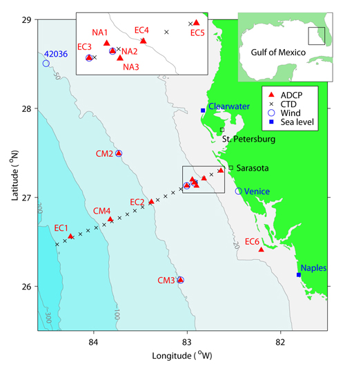
Map of the WFS showing bottom topography, ADCP mooring stations, CTD transect offshore Sarasota, wind and coastal sea level stations. Enlarged inner WFS near Sarasota is shown as an inset map in the upper-left corner. The relative location of the WFS is shown in a Gulf of Mexico map inserted in the upper-right corner. |
See the citations of this paper [Liu and Weisberg, 2005] in Google Scholar.